
Bowstring Lake, Minnesota
Bowstring Lake Fishing Guide: A Broad, Shallow Multi-Species Fishery
This Bowstring Lake Fishing Guide brings together verified lake facts, every DNR-listed fish species, seasonal context, public access information, map resources, and practical trip-planning insight for anglers.
Bowstring Lake lies northwest of Deer River in Itasca County and covers more than 9,500 acres. Its 32-foot maximum depth is modest for a lake of this size, while 4,736 acres are classified as littoral habitat. That combination creates an expansive mix of vegetation, flats, shoreline breaks, and open-water transitions.
Water clarity averages 5.3 feet in the current Minnesota DNR record. As a result, wind, water color, vegetation, and subtle bottom changes can be more useful than searching only for sharp contours. The lake can support walleye and northern pike while also offering bluegill, black crappie, yellow perch, and other panfish opportunities.
The September 2025 night-electrofishing survey did not collect young-of-the-year walleye at the seven sampled stations. However, the DNR specifically noted that low water and increased vegetation made traditional stations harder to evaluate. That single sampling event should not be treated as proof of future fishing quality.
How to Use This Bowstring Lake Fishing Guide
Bowstring rewards a zone-based approach. First, separate shallow vegetation and protected bays from wind-exposed flats, shoreline breaks, and the lake’s limited deeper water. Then compare several areas within the same zone before deciding whether the pattern is productive.
Meanwhile, the latest DNR work should be read in context. Ten adult walleye were observed during the 2025 electrofishing effort and appeared to be in good condition, even though no age-zero fish were collected. Largemouth bass and panfish were more prominent in the sampled shoreline stations.
Because faucet snails and zebra mussels are listed in the lake, anglers should expect habitat and water clarity to continue changing over time. Those changes can affect vegetation, forage location, and how fish use the same piece of structure from one season to the next.
For that reason, a practical day begins with wind direction, water temperature, and a short route through connected areas. A guide can help narrow the lake quickly and explain why one vegetation edge or flat is more useful than another.
Reading Bowstring Lake Structure
Bowstring is not defined by one dramatic deep basin. Instead, broad shallow zones, vegetation lines, shoreline points, and gradual drops create many small decisions. The contour map is most useful for finding where those elements compress or connect.
Because the lake is large and relatively shallow, wind can reshape both boat control and feeding activity. A windward edge may gain color and forage, while an exposed crossing can become uncomfortable quickly. Build the route around safe travel as well as fishing potential.
Finally, treat vegetation as structure. Note its outside edge, height, density, and relationship to clean bottom or nearby depth. Repeating those details is more useful than covering random shoreline.
Find the lake
Bowstring Lake Location
Bowstring Lake is in Itasca County near Deer River, Minnesota. This embedded Bowstring Lake map uses the center coordinates in the DNR record so visitors can review surrounding roads before choosing an access.
Lake center: 47.536117, -93.91634
Use this Bowstring Lake map location for trip planning, then confirm the exact launch before towing to the lake.
The fishery
Bowstring Lake Fishing Guide: Species and Survey Context
Bowstring Lake has 17 fish species in the Minnesota DNR record. The four cards introduce prominent targets and food-web roles, while the guide below covers the complete DNR list without pretending every species offers the same angling opportunity.
Classic target
Walleye
The latest DNR report describes the 2025 electrofishing result as a difficult shoreline sample, not a dependable forecast. Bowstring still remains managed and known as a walleye lake.
Ambush predator
Northern Pike
Pike can use weedlines, shallow flats, shoreline breaks, and open-water forage. Their position can change quickly with wind, temperature, and vegetation.
Protected-water opportunity
Crappie and Bluegill
Black crappie and bluegill add a strong panfish component around vegetation, bays, wood, and nearby edges.
Food-web connection
Yellow Perch and Cisco
Yellow perch and cisco help connect shallow and open-water habitat to the lake’s larger predators.
Interactive species guide
Meet the Fish of Bowstring Lake
Bowstring’s broad shallows support far more than its headline walleye and pike fishery. Choose a species to connect reliable field marks with this lake’s vegetation, flats, gradual breaks, and limited deep water.
17DNR-listed species
Walleye selected.
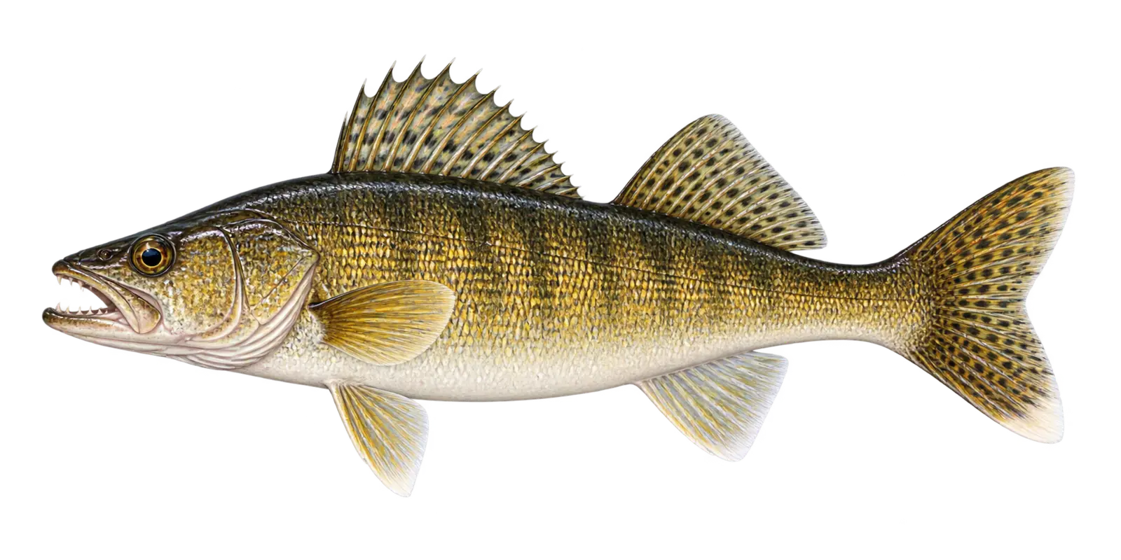 White lower tail tip and reflective eye
Classic target
Walleye
Sander vitreus
- Spring
- Summer
- Fall
- Winter
In particular, consider Walleye within Bowstring Lake’s broad, relatively shallow fishery. Within Bowstring Lake, walleye are built for low-light feeding. Across Bowstring Lake, wind, cloud cover, dawn, dusk, water color, and access to depth can all affect their position.
How to recognize it
For example, use these marks for a Bowstring Lake field check. On Bowstring Lake, a large glassy eye and bright white lower tip of the tail are the easiest field marks. Around Bowstring Lake, the mouth has noticeable canine teeth.
Bowstring Lake survey snapshot
The September 2025 night-electrofishing survey collected no young-of-the-year walleye at seven stations. However, low water and increased vegetation made traditional sampling areas difficult to evaluate, and ten adult walleye were observed in good condition.
Where it fits here
Meanwhile, in Bowstring Lake, wind-touched flats, shoreline breaks, and clean transitions beside vegetation are the most useful local reference points.
Often confused with
By contrast, compare these marks before naming a Bowstring Lake catch. On Bowstring Lake, sauger have rows of black spots on the dorsal fin and lack the walleye’s clear white lower tail tip.
Starting depth zone
Low-light shallows through deeper structureDepth changes with light, wind, forage, and season.
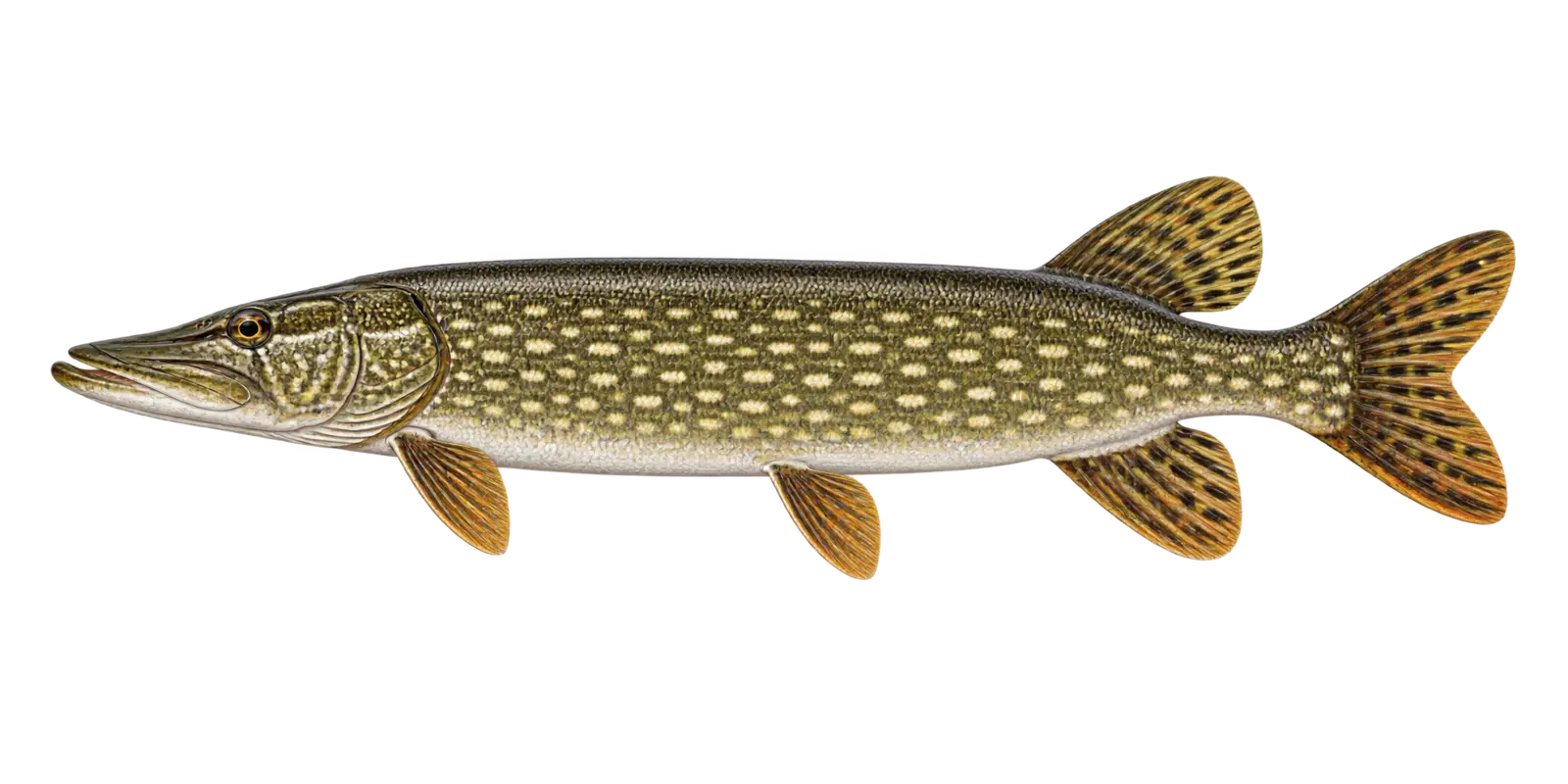 Light spots on a dark body
Primary predator
Northern Pike
Esox lucius
- Spring
- Fall
- Winter
In particular, consider Northern Pike within Bowstring Lake’s broad, relatively shallow fishery. Within Bowstring Lake, northern pike are fast ambush predators that may use shallow vegetation, breaklines, points, and deeper structure as conditions change.
How to recognize it
For example, use these marks for a Bowstring Lake field check. On Bowstring Lake, look for a long torpedo body, a broad duckbill snout, pale bean-shaped spots on darker green sides, and a dorsal fin near the tail.
Bowstring Lake survey snapshot
The 2021 DNR sampling measured 234 Northern Pike from 14 to 32 inches. However, those sampled Bowstring Lake fish are a survey snapshot rather than a current population count.
Where it fits here
Meanwhile, in Bowstring Lake, weed edges, points, and nearby deeper water let predators move with perch and other forage.
Often confused with
By contrast, compare these marks before naming a Bowstring Lake catch. On Bowstring Lake, muskellunge usually show dark markings on a lighter body. Around Bowstring Lake, northern pike show lighter spots on a darker body.
Starting depth zone
Vegetation, breaks, and deeper structureA flexible zone, not an exact fishing location.
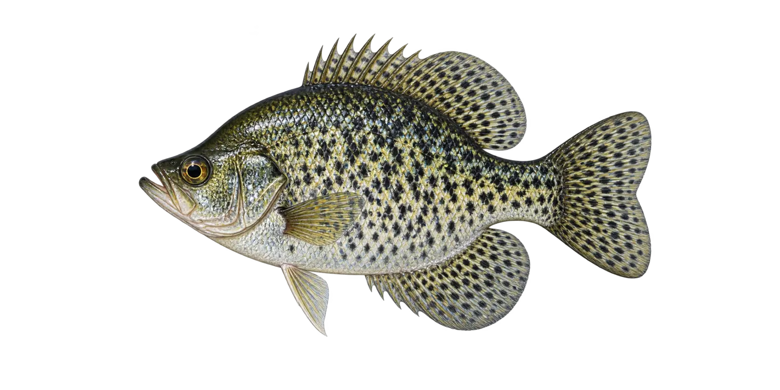 Irregular black mottling
Panfish
Black Crappie
Pomoxis nigromaculatus
- Spring
- Summer
- Winter
In particular, consider Black Crappie within Bowstring Lake’s broad, relatively shallow fishery. Within Bowstring Lake, black crappie often travel in loose schools and may hold around vegetation, wood, or suspended over deeper water.
How to recognize it
For example, use these marks for a Bowstring Lake field check. On Bowstring Lake, look for a deep compressed body covered with irregular black blotches, a slightly upturned mouth, and seven or eight dorsal spines.
Bowstring Lake survey snapshot
The 2021 DNR sampling measured 51 Black Crappie from 4 to 12 inches. However, those sampled Bowstring Lake fish are a survey snapshot rather than a current population count.
Where it fits here
Meanwhile, in Bowstring Lake, protected bays, shoreline vegetation, wood, and outside weed edges provide a practical shallow-to-deep search path.
Often confused with
By contrast, compare these marks before naming a Bowstring Lake catch. On Bowstring Lake, white crappie usually show organized vertical bars and have fewer dorsal spines. Around Bowstring Lake, black crappie look more randomly mottled.
Starting depth zone
Cover, weed edges, and suspended schoolsCrappie depth can change quickly during the day.
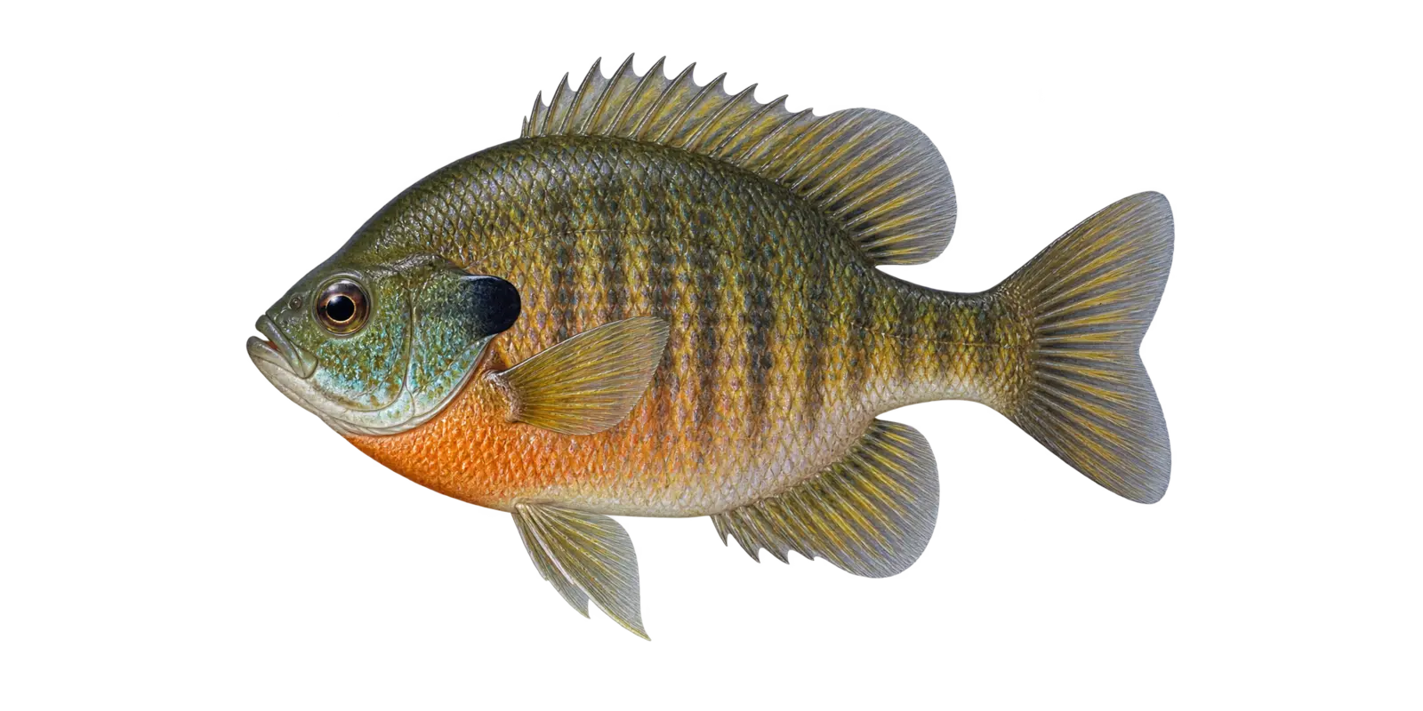 Dark ear flap and small mouth
Panfish
Bluegill
Lepomis macrochirus
- Spring
- Summer
- Winter
In particular, consider Bluegill within Bowstring Lake’s broad, relatively shallow fishery. Within Bowstring Lake, bluegill are one of the easiest fish for a new angler to recognize and often relate to vegetation, protected shoreline, and nearby cover.
How to recognize it
For example, use these marks for a Bowstring Lake field check. On Bowstring Lake, look for a deep round body, a small mouth, blue-green color on the cheek and throat, faint vertical bars, and a solid dark ear flap.
Bowstring Lake survey snapshot
The 2021 DNR sampling measured 2 Bluegill at 8 inches. However, that limited Bowstring Lake measurement does not describe the lake’s full size range.
Where it fits here
Meanwhile, in Bowstring Lake, protected bays, shoreline vegetation, wood, and outside weed edges provide a practical shallow-to-deep search path.
Often confused with
By contrast, compare these marks before naming a Bowstring Lake catch. On Bowstring Lake, pumpkinseed have bright blue facial lines and a red-orange crescent on the rear edge of the ear flap.
Starting depth zone
Shallow weeds, cover, and nearby edgesSchools can shift deeper during bright or warm periods.
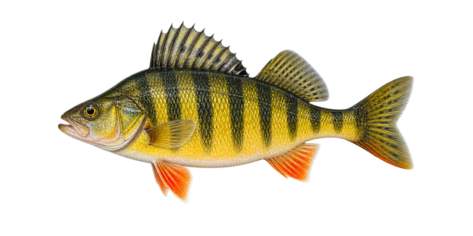 Dark bars and orange lower fins
Panfish and forage
Yellow Perch
Perca flavescens
- Spring
- Fall
- Winter
In particular, consider Yellow Perch within Bowstring Lake’s broad, relatively shallow fishery. Within Bowstring Lake, yellow perch are both an angling opportunity and an important prey fish that may gather in schools over flats and along edges.
How to recognize it
For example, use these marks for a Bowstring Lake field check. On Bowstring Lake, the golden-yellow body, six to eight dark vertical bars, orange lower fins, and two separate dorsal fins are easy field marks.
Bowstring Lake survey snapshot
The 2021 DNR sampling measured 117 Yellow Perch from 5 to 11 inches. However, those sampled Bowstring Lake fish are a survey snapshot rather than a current population count.
Where it fits here
Meanwhile, in Bowstring Lake, vegetated flats and edges leading toward open water let schools shift with light, forage, and season.
Often confused with
By contrast, compare these marks before naming a Bowstring Lake catch. On Bowstring Lake, young walleye are less yellow, show different mottling, and have the characteristic white lower tail tip.
Starting depth zone
Flats, weed edges, and basin transitionsPerch can roam from shallow water to deeper schools.
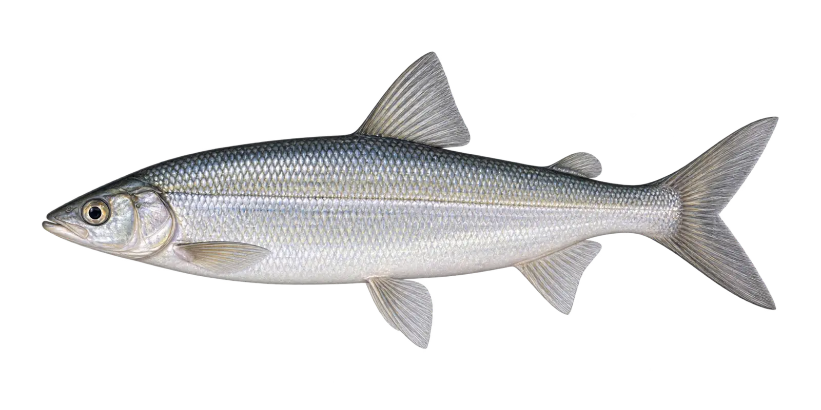 Silver body and forward lower jaw
Cold-water forage fish
Tullibee (Cisco)
Coregonus artedi
- Summer deep water
- Fall spawning
In particular, consider Tullibee (Cisco) within Bowstring Lake’s broad, relatively shallow fishery. Within Bowstring Lake, cisco connect cold basin habitat to predator fisheries. Across Bowstring Lake, their depth and abundance can influence where larger fish travel.
How to recognize it
For example, use these marks for a Bowstring Lake field check. On Bowstring Lake, look for bright silver sides, a deeply forked tail, a small adipose fin, and a lower jaw that reaches to or beyond the snout.
Bowstring Lake survey snapshot
The 2021 DNR sampling measured 22 Tullibee (Cisco) from 8 to 17 inches. However, those sampled Bowstring Lake fish are a survey snapshot rather than a current population count.
Where it fits here
Meanwhile, in Bowstring Lake, the lake’s limited deeper water and remaining cool-water transitions matter more than its expansive warm shallows.
Often confused with
By contrast, compare these marks before naming a Bowstring Lake catch. On Bowstring Lake, lake whitefish have a more overhanging snout and a small mouth set below it. Around Bowstring Lake, cisco have a more forward lower jaw.
Starting depth zone
Cold, oxygenated basin waterWarm-water handling at depth deserves extra care.
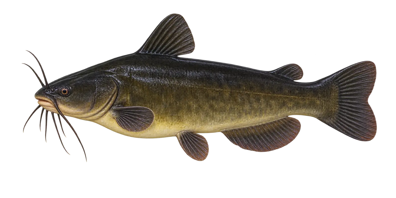 Dark body, dark chin barbels, rounded tail
Native bullhead
Black Bullhead
Ameiurus melas
- Spring
- Summer
- Fall
In particular, consider Black Bullhead within Bowstring Lake’s broad, relatively shallow fishery. Within Bowstring Lake, black bullheads are hardy bottom-oriented catfish that feed on insects, small fish, and other food close to the lake floor.
How to recognize it
For example, use these marks for a Bowstring Lake field check. On Bowstring Lake, look for a dark olive to nearly black body, dark chin barbels, a broad head, and a tail that is squared or only slightly notched.
Bowstring Lake survey snapshot
The 2021 DNR sampling measured 24 Black Bullhead from 6 to 10 inches. However, those sampled Bowstring Lake fish are a survey snapshot rather than a current population count.
Where it fits here
Meanwhile, in Bowstring Lake, gradual slopes and firm-to-soft bottom changes connect shallow feeding water to the lake’s modest basin.
Often confused with
By contrast, compare these marks before naming a Bowstring Lake catch. On Bowstring Lake, yellow bullheads have pale chin barbels. Around Bowstring Lake, brown bullheads are usually more mottled and may show a more noticeable tail notch.
Starting depth zone
Protected bays and soft-bottom edgesBottom cover matters more than one exact depth.
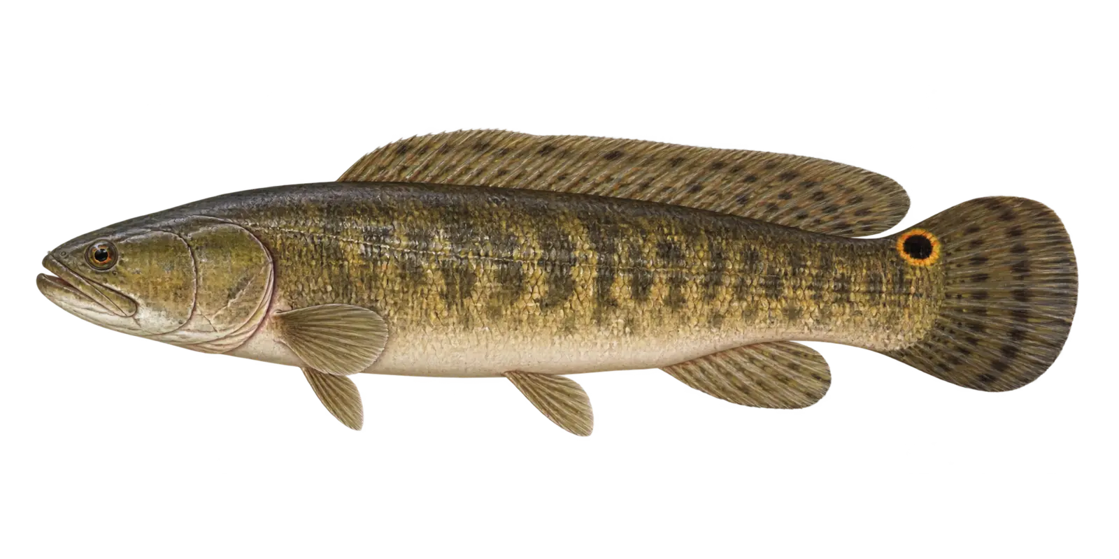 Long dorsal fin and rounded tail
Native predator
Bowfin (Dogfish)
Amia calva
- Spring
- Summer
In particular, consider Bowfin (Dogfish) within Bowstring Lake’s broad, relatively shallow fishery. Within Bowstring Lake, bowfin are an ancient native fish, not an invasive species. Across Bowstring Lake, they can breathe air at the surface and tolerate warm, weedy, lower-oxygen habitat.
How to recognize it
For example, use these marks for a Bowstring Lake field check. On Bowstring Lake, the long low dorsal fin runs across more than half the back, the tail is rounded, and males may show a dark eyespot near the tail.
Bowstring Lake survey snapshot
The 2021 DNR sampling measured 1 Bowfin (Dogfish) at 24 inches. However, that limited Bowstring Lake measurement does not describe the lake’s full size range.
Where it fits here
Meanwhile, in Bowstring Lake, warm vegetated bays and protected cover match this hardy native fish particularly well.
Often confused with
By contrast, compare these marks before naming a Bowstring Lake catch. On Bowstring Lake, burbot have a chin barbel and two dorsal fins. Around Bowstring Lake, bowfin have no chin barbel and one very long continuous dorsal fin.
Starting depth zone
Shallow, warm, weedy coverA cover-oriented native predator.
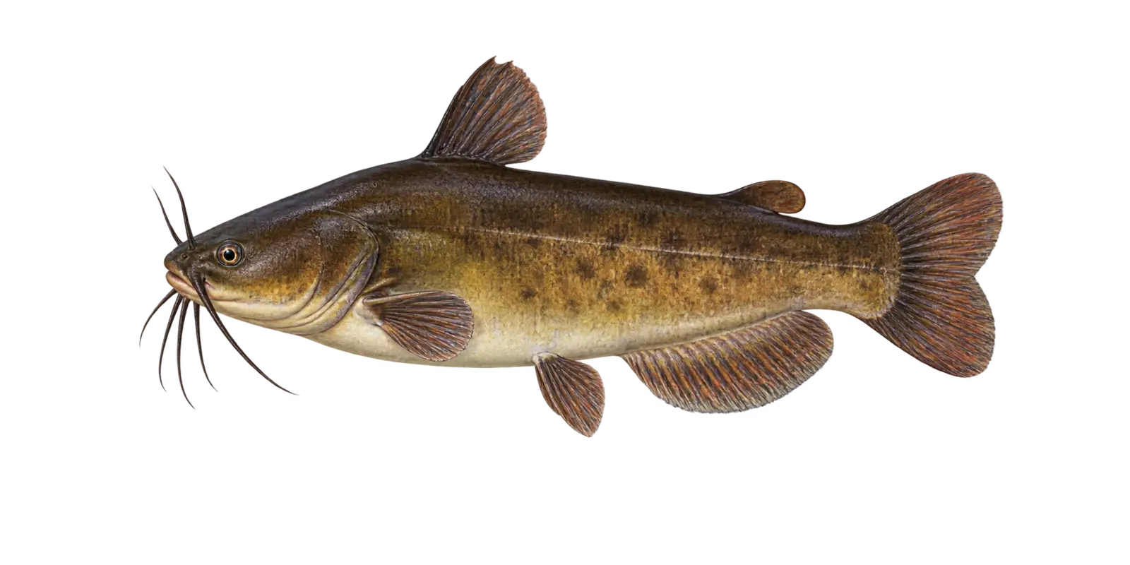 Mottled brown sides and dark barbels
Native bullhead
Brown Bullhead
Ameiurus nebulosus
- Spring
- Summer
- Fall
In particular, consider Brown Bullhead within Bowstring Lake’s broad, relatively shallow fishery. Within Bowstring Lake, brown bullheads are bottom-feeding catfish that use protected bays, soft substrates, and low-light shoreline habitat.
How to recognize it
For example, use these marks for a Bowstring Lake field check. On Bowstring Lake, the body is olive-brown with mottling, the chin barbels are dark, and the tail is slightly notched rather than deeply forked.
Bowstring Lake survey snapshot
The 2021 DNR sampling measured 11 Brown Bullhead from 9 to 13 inches. However, those sampled Bowstring Lake fish are a survey snapshot rather than a current population count.
Where it fits here
Meanwhile, in Bowstring Lake, gradual slopes and firm-to-soft bottom changes connect shallow feeding water to the lake’s modest basin.
Often confused with
By contrast, compare these marks before naming a Bowstring Lake catch. On Bowstring Lake, yellow bullheads have pale chin barbels. Around Bowstring Lake, black bullheads are usually darker and less distinctly mottled.
Starting depth zone
Soft bottom and protected shoreline waterA broad bottom zone rather than a precise contour.
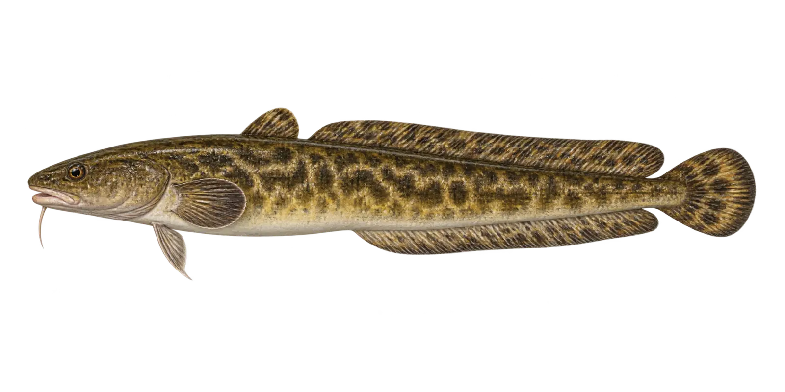 Chin barbel and eel-like body
Cold-water predator
Burbot
Lota lota
- Winter
- Early spring
In particular, consider Burbot within Bowstring Lake’s broad, relatively shallow fishery. Within Bowstring Lake, burbot are the only freshwater member of the cod family in Minnesota and are especially active in cold water.
How to recognize it
For example, use these marks for a Bowstring Lake field check. On Bowstring Lake, look for an eel-like mottled body, one barbel under the chin, two dorsal fins, and a rounded tail.
Bowstring Lake survey snapshot
The 2021 DNR sampling documented 23 Burbot in backpack electrofishing. However, a Bowstring Lake gear-specific catch should not be treated as a full population estimate.
Where it fits here
Meanwhile, in Bowstring Lake, the lake’s limited deeper water and remaining cool-water transitions matter more than its expansive warm shallows.
Often confused with
By contrast, compare these marks before naming a Bowstring Lake catch. On Bowstring Lake, bowfin have no chin barbel and one long continuous dorsal fin. Around Bowstring Lake, burbot have two distinct dorsal fins.
Starting depth zone
Cool bottom water and winter spawning routesCold water is the strongest habitat clue.
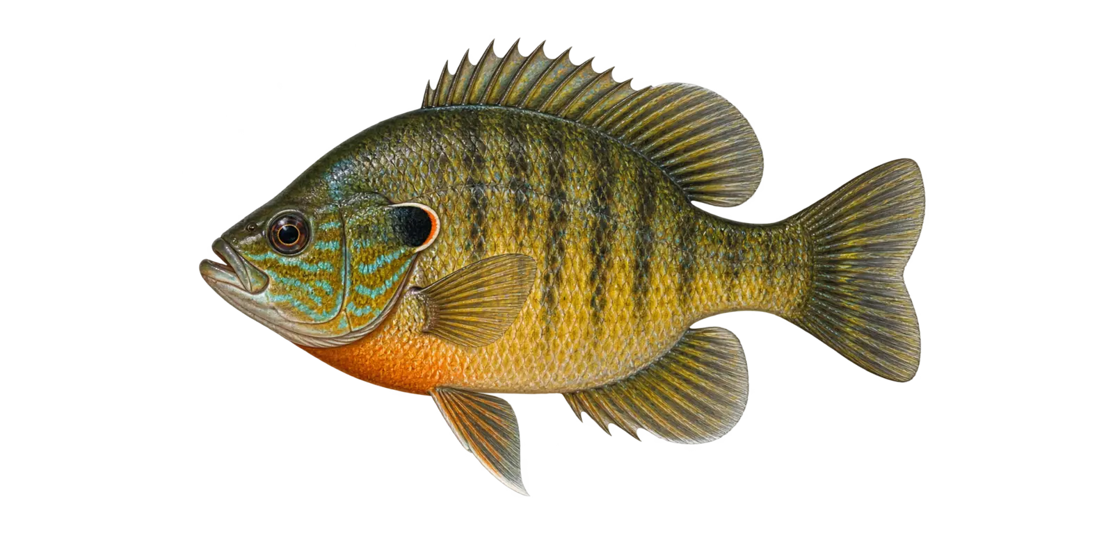 A variable mix of sunfish field marks
Sunfish hybrid
Hybrid Sunfish
Lepomis hybrid
- Spring
- Summer
- Winter
In particular, consider Hybrid Sunfish within Bowstring Lake’s broad, relatively shallow fishery. Within Bowstring Lake, hybrid sunfish combine traits from two parent species, so color, body shape, mouth size, and ear-flap markings can vary.
How to recognize it
For example, use these marks for a Bowstring Lake field check. On Bowstring Lake, expect a deep sunfish body with a mixture of bluegill, green sunfish, pumpkinseed, or other Lepomis features.
Bowstring Lake survey snapshot
The 2021 DNR sampling measured 4 Hybrid Sunfish from 7 to 9 inches. However, those sampled Bowstring Lake fish are a survey snapshot rather than a current population count.
Where it fits here
Meanwhile, in Bowstring Lake, protected bays, shoreline vegetation, wood, and outside weed edges provide a practical shallow-to-deep search path.
Often confused with
By contrast, compare these marks before naming a Bowstring Lake catch. On Bowstring Lake, a pure bluegill or pumpkinseed usually shows a more consistent set of field marks. Around Bowstring Lake, some hybrids require expert identification.
Starting depth zone
Vegetation, cover, and nearby shoreline edgesHabitat often resembles the parent sunfish species.
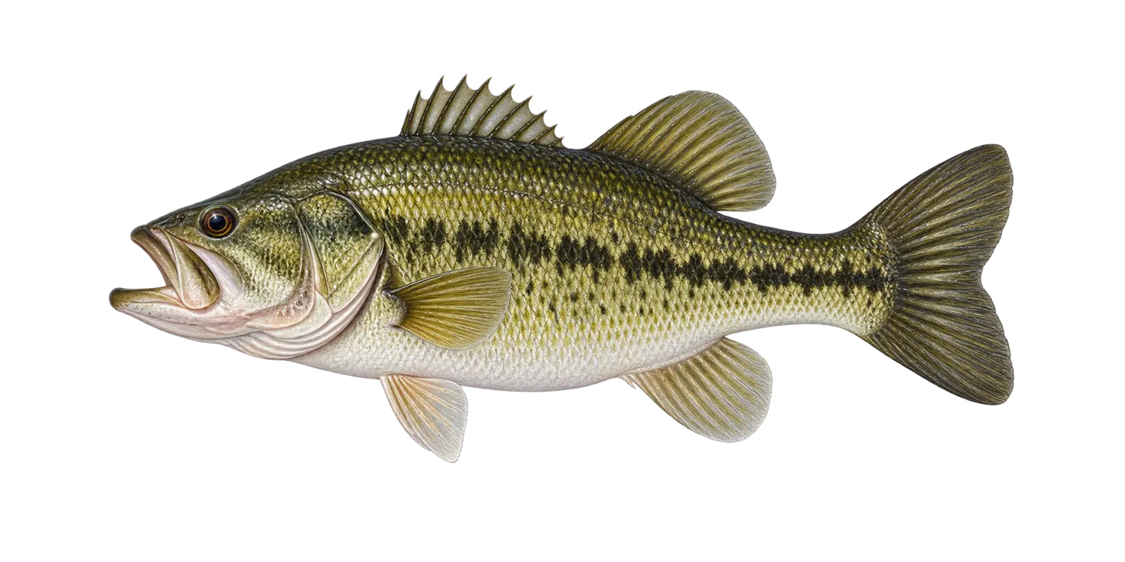 Large jaw and dark side stripe
Cover-oriented game fish
Largemouth Bass
Micropterus salmoides
- Spring
- Summer
- Fall
In particular, consider Largemouth Bass within Bowstring Lake’s broad, relatively shallow fishery. Within Bowstring Lake, largemouth bass are cover-oriented predators that use vegetation, wood, protected bays, and nearby depth.
How to recognize it
For example, use these marks for a Bowstring Lake field check. On Bowstring Lake, the upper jaw extends behind the eye, a bold broken dark stripe runs along the side, and a deep notch divides the dorsal fin.
Bowstring Lake survey snapshot
The 2021 DNR sampling measured 12 Largemouth Bass from 4 to 18 inches. However, those sampled Bowstring Lake fish are a survey snapshot rather than a current population count.
Where it fits here
Meanwhile, in Bowstring Lake, warm vegetation, wood, and protected shoreline cover fit the lake’s bass habitat better than an offshore-only plan.
Often confused with
By contrast, compare these marks before naming a Bowstring Lake catch. On Bowstring Lake, smallmouth bass have vertical bars and a smaller jaw that usually ends near the middle of the eye.
Starting depth zone
Vegetation, shoreline cover, and nearby dropsCover and access to depth matter more than one number.
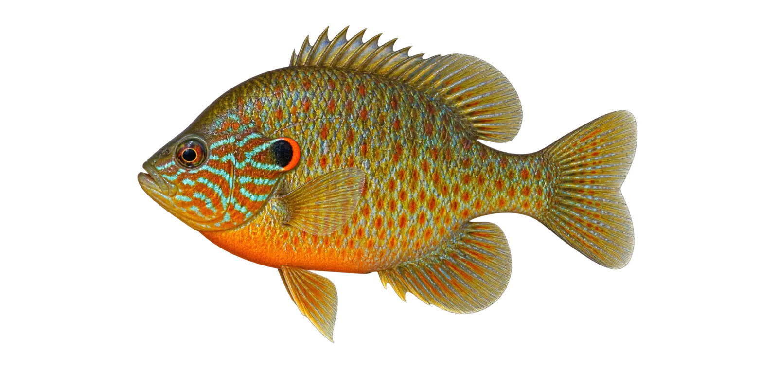 Blue face lines and orange ear crescent
Colorful panfish
Pumpkinseed
Lepomis gibbosus
- Spring
- Summer
In particular, consider Pumpkinseed within Bowstring Lake’s broad, relatively shallow fishery. Within Bowstring Lake, pumpkinseed are colorful shoreline sunfish that commonly use shallow vegetation and firm-bottom areas with small invertebrates.
How to recognize it
For example, use these marks for a Bowstring Lake field check. On Bowstring Lake, look for bright blue-green wavy lines on the cheek and a black ear flap ending in a red-orange crescent.
Bowstring Lake survey snapshot
The 2021 DNR sampling measured 25 Pumpkinseed from 3 to 8 inches. However, those sampled Bowstring Lake fish are a survey snapshot rather than a current population count.
Where it fits here
Meanwhile, in Bowstring Lake, protected bays, shoreline vegetation, wood, and outside weed edges provide a practical shallow-to-deep search path.
Often confused with
By contrast, compare these marks before naming a Bowstring Lake catch. On Bowstring Lake, bluegill have a plain dark ear flap without the pumpkinseed’s bright crescent and bold blue facial lines.
Starting depth zone
Very shallow vegetation and firm shorelineA shoreline-oriented sunfish in open water.
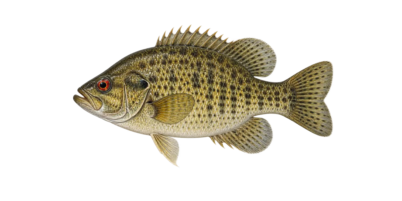 Red eye and mottled body
Cover-oriented panfish
Rock Bass
Ambloplites rupestris
- Spring
- Summer
- Fall
In particular, consider Rock Bass within Bowstring Lake’s broad, relatively shallow fishery. Within Bowstring Lake, rock bass are sturdy cover fish with a large mouth. Across Bowstring Lake, rock, wood, shade, and firm shoreline edges are useful habitat clues.
How to recognize it
For example, use these marks for a Bowstring Lake field check. On Bowstring Lake, a deep red-orange eye, olive-bronze mottling, a stout body, and a mouth larger than most sunfish are the quickest clues.
Bowstring Lake survey snapshot
The 2021 DNR sampling measured 1 Rock Bass at 10 inches. However, that limited Bowstring Lake measurement does not describe the lake’s full size range.
Where it fits here
Meanwhile, in Bowstring Lake, protected bays, shoreline vegetation, wood, and outside weed edges provide a practical shallow-to-deep search path.
Often confused with
By contrast, compare these marks before naming a Bowstring Lake catch. On Bowstring Lake, crappie have a thinner profile. Around Bowstring Lake, smallmouth bass are more elongated and lack the classic rock bass body shape.
Starting depth zone
Rock, wood, and firm edgesCover is usually the more useful clue.
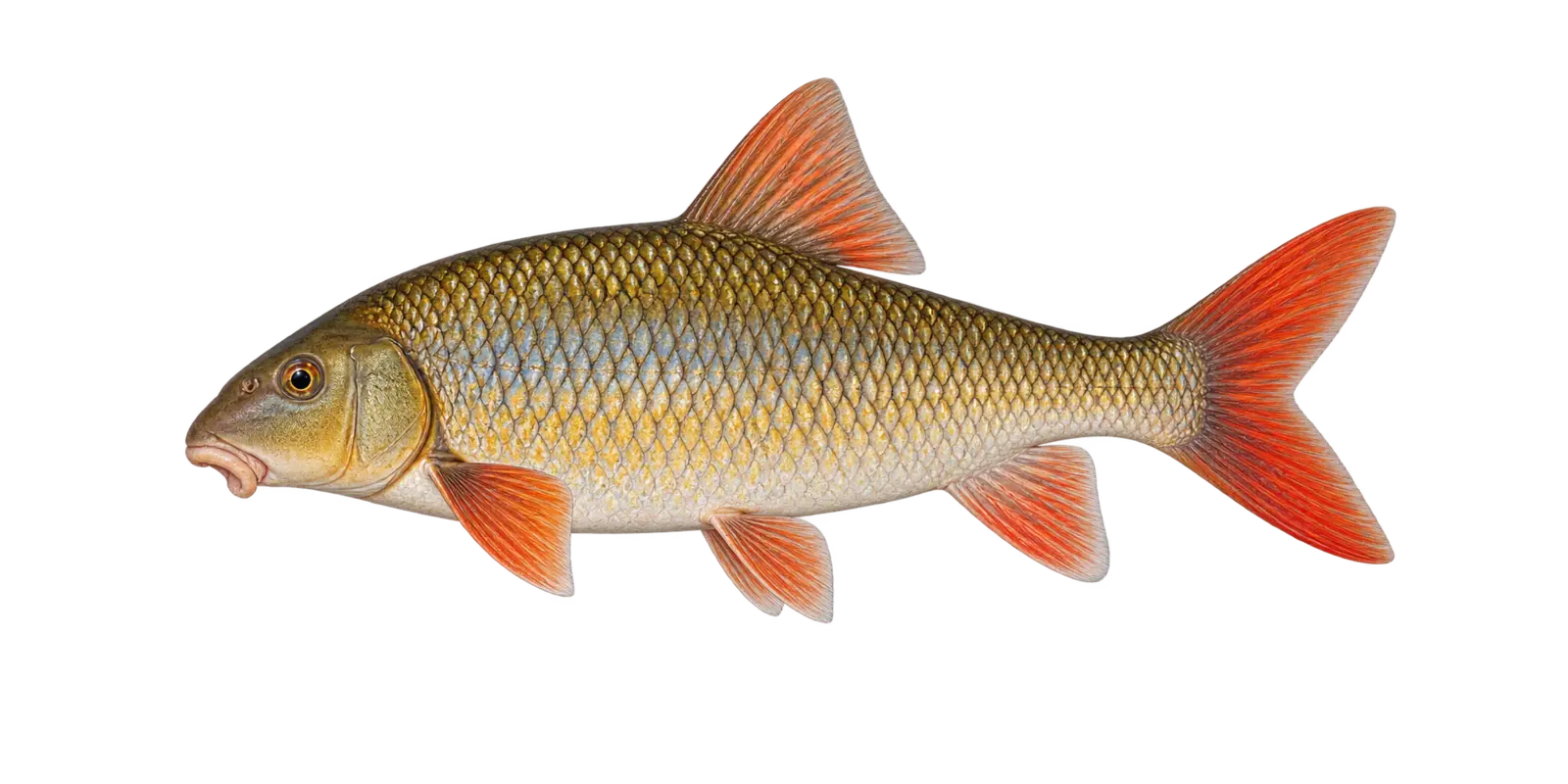 Short head and red-orange lower fins
Native redhorse
Shorthead Redhorse
Moxostoma macrolepidotum
- Spring movement
- Summer
- Fall
In particular, consider Shorthead Redhorse within Bowstring Lake’s broad, relatively shallow fishery. Within Bowstring Lake, shorthead redhorse are native bottom feeders that use a fleshy sucker mouth to collect insects and other food from the substrate.
How to recognize it
For example, use these marks for a Bowstring Lake field check. On Bowstring Lake, look for a relatively short head, a silver-bronze body, large scales, and orange to red color in the lower fins and tail.
Bowstring Lake survey snapshot
The 2021 DNR sampling measured 8 Shorthead Redhorse from 14 to 19 inches. However, those sampled Bowstring Lake fish are a survey snapshot rather than a current population count.
Where it fits here
Meanwhile, in Bowstring Lake, gradual slopes and firm-to-soft bottom changes connect shallow feeding water to the lake’s modest basin.
Often confused with
By contrast, compare these marks before naming a Bowstring Lake catch. On Bowstring Lake, other redhorse species are very similar. Around Bowstring Lake, lip shape, head proportions, and scale counts may be needed for certainty.
Starting depth zone
Firm bottom, gravel, and connected-water habitatBottom type often matters more than exact depth.
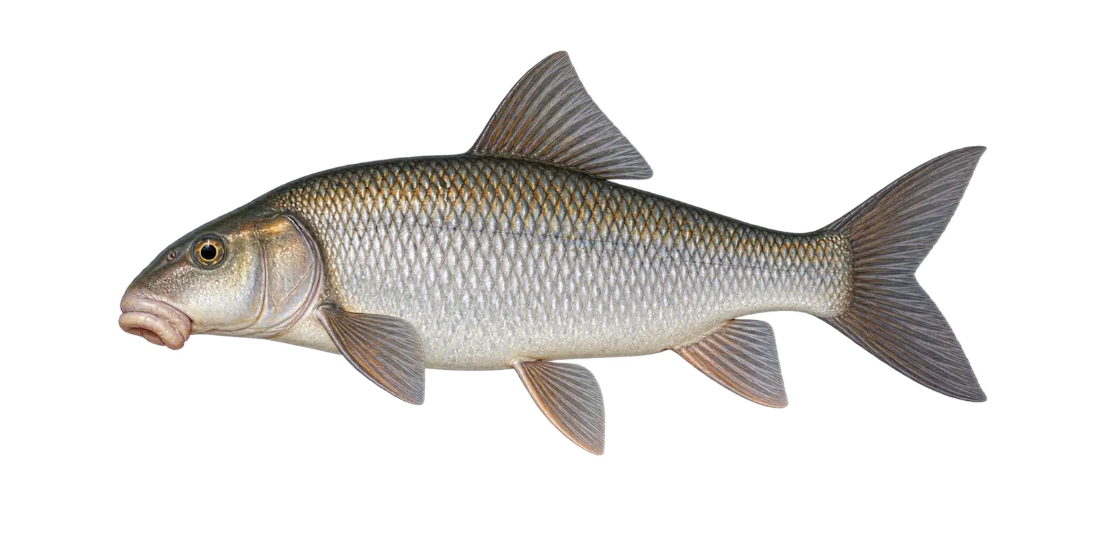 Silver-bronze body and fleshy lower lips
Native redhorse
Silver Redhorse
Moxostoma anisurum
- Spring movement
- Summer
- Fall
In particular, consider Silver Redhorse within Bowstring Lake’s broad, relatively shallow fishery. Within Bowstring Lake, silver redhorse are large native suckers that feed on insects and other small organisms along the bottom.
How to recognize it
For example, use these marks for a Bowstring Lake field check. On Bowstring Lake, look for a robust silver-bronze body, a fleshy underslung mouth, large scales, and reddish color in the lower fins.
Bowstring Lake survey snapshot
Minnesota DNR LakeFinder lists Silver Redhorse in Bowstring Lake. However, the latest broad survey summary for Bowstring Lake does not provide a dependable species-specific size estimate for this listing.
Where it fits here
Meanwhile, in Bowstring Lake, gradual slopes and firm-to-soft bottom changes connect shallow feeding water to the lake’s modest basin.
Often confused with
By contrast, compare these marks before naming a Bowstring Lake catch. On Bowstring Lake, golden, greater, and shorthead redhorse overlap in appearance. Around Bowstring Lake, positive identification may require close inspection.
Starting depth zone
Firm bottom and connected-water transitionsSubstrate and current are central clues.
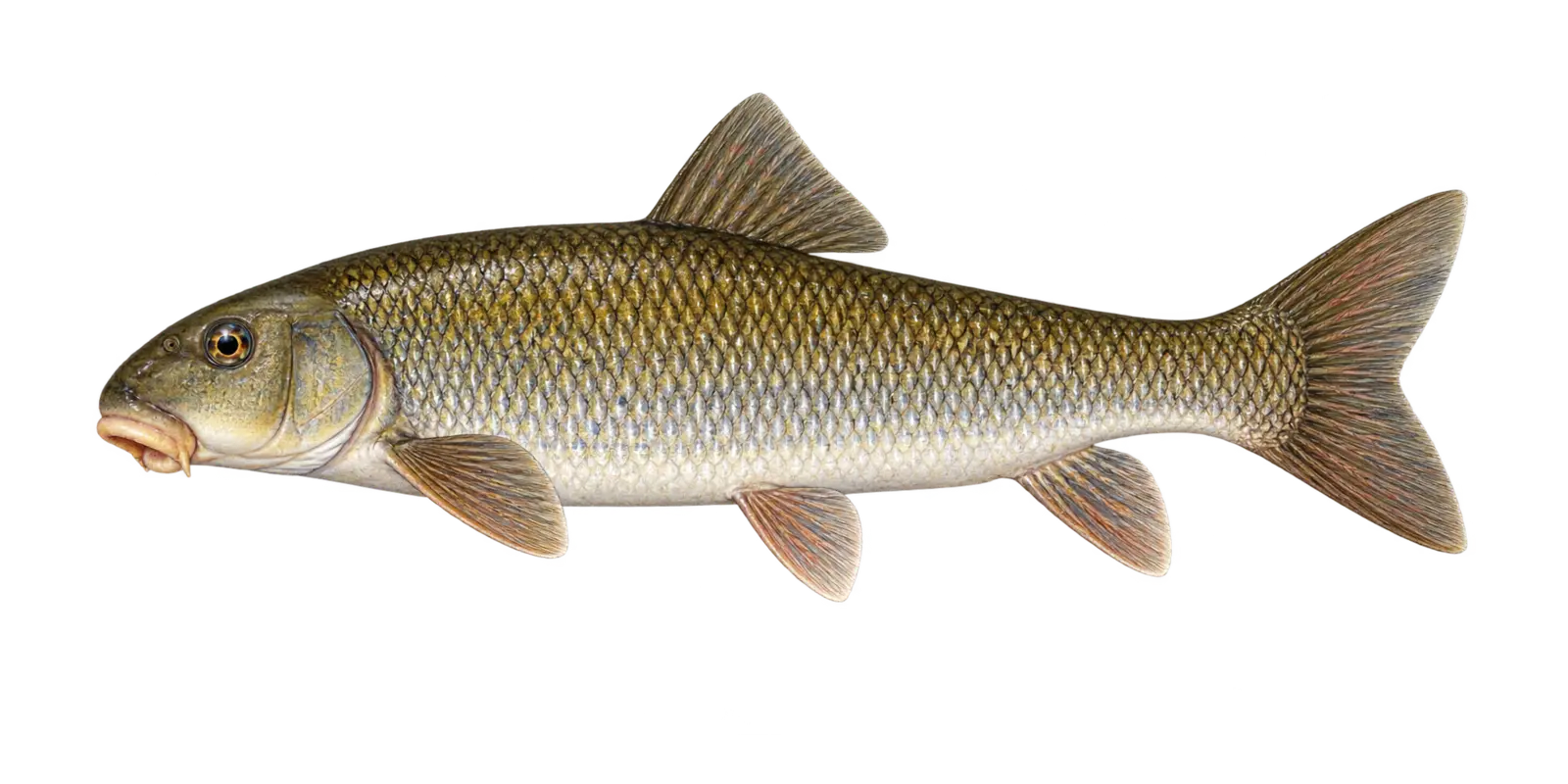 Downturned sucker mouth
Native bottom feeder
White Sucker
Catostomus commersonii
- Spring movement
- Year-round habitat
In particular, consider White Sucker within Bowstring Lake’s broad, relatively shallow fishery. Within Bowstring Lake, white suckers feed along the bottom on insects, small organisms, and organic material and are a normal native part of the food web.
How to recognize it
For example, use these marks for a Bowstring Lake field check. On Bowstring Lake, look for a blunt snout, a fleshy mouth set under the head, large obvious scales, and a long silver-bronze body without barbels.
Bowstring Lake survey snapshot
The 2021 DNR sampling measured 37 White Sucker from 7 to 18 inches. However, those sampled Bowstring Lake fish are a survey snapshot rather than a current population count.
Where it fits here
Meanwhile, in Bowstring Lake, gradual slopes and firm-to-soft bottom changes connect shallow feeding water to the lake’s modest basin.
Often confused with
By contrast, compare these marks before naming a Bowstring Lake catch. On Bowstring Lake, redhorse species often have red-orange fins and different lip shapes. Around Bowstring Lake, carp have mouth barbels; white suckers do not.
Starting depth zone
Bottom habitat across a broad depth rangeThe lake bottom is the key relationship.
Plain-English fish glossary
- Breakline
- A place where the bottom changes depth more quickly.
- Forage fish
- A fish that is an important food source for larger predators.
- Littoral zone
- Shallower water where enough light reaches the bottom for plants to grow.
- Adipose fin
- A small fleshy fin between the main dorsal fin and tail on fish such as cisco.
- Trap net
- A passive DNR sampling net often used near shore. Its catch is not a direct count of every fish in the lake.
- Gill net
- A DNR survey net used to sample open-water fish. Results describe that sampling effort, not a current bite report.
Bowstring Lake species names, measurements, and survey notes follow Minnesota DNR LakeFinder records, while the illustrations emphasize practical field marks rather than documenting a particular catch. Survey results for Bowstring Lake remain snapshots, not promises about present abundance or fishing success.
JavaScript is needed to switch the Bowstring Lake fish cards. Visitors researching Bowstring Lake can also use the Minnesota DNR fish guide at dnr.state.mn.us/fish.
DNR survey context
What the Recent Surveys Tell Us
- September 16, 2025: The September 2025 night-electrofishing survey found no young-of-the-year Walleye at the seven stations sampled. Meanwhile, the DNR cautioned that low water and increased vegetation after zebra mussel establishment made the traditional sampling areas more difficult to evaluate.
- In addition, Ten adult Walleye were observed and appeared to be in good condition.
- Notably, Largemouth Bass and panfish were more prominent in the sampled stations.
- Finally, One survey event is not a dependable forecast of future year-class strength or angling success.
Read the complete Bowstring Lake Minnesota DNR survey record
Seasonal starting points
Bowstring Lake Fishing Guide by Season
Use these Bowstring Lake patterns as a starting framework rather than a promise about one day. On Bowstring Lake, water temperature, wind, forage movement, and recent weather should determine the final location and presentation.
Spring
After ice-out, warming bays, inflows, and early vegetation can organize the shallow fishery. Walleye movements are connected to spawning and recovery, while pike remain active near vegetation and protected shoreline. Cold water favors deliberate speed.
Summer
As vegetation develops, outside weed edges, broad flats, gradual breaks, and wind-driven water become important. Meanwhile, the lake’s modest depth means weather can affect a large portion of the fishery at once.
Fall
Cooling water can renew activity along remaining green weeds, shoreline breaks, and open flats. Because Bowstring is exposed, build several protected alternatives into the plan before strong fall weather arrives.
Winter
Bowstring supports winter opportunities for walleye, pike, perch, crappie, and other panfish. However, pressure ridges, access conditions, and ice thickness vary. Verify local conditions and check the route continuously.
Plan before you launch
Bowstring Lake Fishing Guide: Map, Access, and Official Resources
Select the optimized Minnesota DNR contour map for Bowstring Lake to open a large viewer, then confirm current access, regulations, and licensing through the official resources.

Before you fish
Bowstring Lake Fishing Guide: Trip Planning Notes
Use these reference points with current Minnesota DNR information when preparing for a day on Bowstring Lake.
Lake Scale
Bowstring covers 9,528.13 acres with 34.1 miles of shoreline. Group nearby areas into a practical route instead of crossing the lake after every unproductive stop.
Shallow Habitat
The DNR lists 4,736 littoral acres and a 32-foot maximum depth. Vegetation, flats, and gradual transitions therefore shape much of the fishery.
Latest Survey Context
The 2025 electrofishing result was affected by low water and heavy vegetation. It should be read as one shoreline sampling event, not a prediction.
Launch Choices
Four public access records offer several starting points. Check current ramp status and choose one that supports the day’s wind and route.
Aquatic Invasive Species
Faucet snails and zebra mussels are listed. Clean, drain, dispose, and inspect anchors, trailers, and equipment before leaving.
Wind Exposure
A large shallow lake can build quickly in strong wind. Keep safe crossings, protected water, and the return route in the plan.
Contour Map Use
Use the Bowstring map to identify compressed contours, points, vegetation transitions, and travel-efficient groups of areas. Treat it as a reference image, not a navigation chart.
Winter Safety
No online guide can confirm ice safety. Check access locally, test ice as you travel, and carry appropriate rescue equipment.
Bowstring Lake catches
Bowstring Lake Fishing Guide: See the Fishery and Plan Your Day
These photos show walleye catches and a successful day on Bowstring Lake. Select an image for a closer look.

